
Search Maps
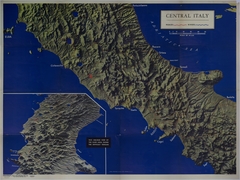
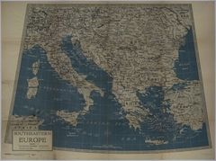
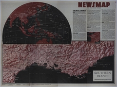
Map # M1749 [1 3/4 inches = 100 miles. Italy: 2 1/4 inches = 20 miles. Inset: 2 3/4 inches = 10 miles]
Map # M1750 [3/4 inch = 50 miles. New Ireland: 1 1/2 inches = 25 miles. Truk: 1 inch = 5 miles. Pacific Theater: None]
Map # M1752 [1 1/4 inches = 100 miles. Burma Insets: 3 inches = 50 miles. New Britain: 1 1/2 inches = 50 miles. Inset of Manus: 2 inches = 50 miles]
Map # M1754 [1/2 inch = 1 mile. Inset of Italy: 3 1/2 inches = 1 mile. Burma: 1 inch = 50 miles. Central Pacific: 1 inch = 100 miles. New Britain: 1 1/2 inches = 100 miles]
Map # M1755 [1 inch = 100 miles. Southwest Pacific: 5 1/2 inches = 100 miles]
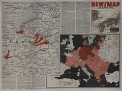
Map # M1756 [1 3/4 inches = 200 miles. Pacific Theater: None. Eastern Front: 1 3/4 inches = 100 miles]
Map # M1759 [1 1/4 inches = 50 miles. Crimea: 1/2 inch = 10 miles]
Map # M1762 [4 3/4 inches = 50 miles. Pacific Theater: 3 1/4 inches = 400 miles]
Map # M1764 [6 1/2 inches = 100 miles. Schouten Islands: 2 1/2 inches = 15 miles. Inset of New Guinea: 1 1/4 inches = 300 miles. Italy: 4 inches = 50 miles]
Map # M649 [3 inches = 100 miles. Inset: None]
Map # M1765 [3 inches = 20 miles. Italy: 5 1/2 inches = 50 miles. Inset of Italy: None. Pacific Theater: 3 3/4 inches = 1000 miles. Eastern Front: 2 1/2 inches = 100 miles]
Map # M1766 [12 3/4 inches = 25 miles. New Guinea: 4 1/2 inches = 500 miles. Eastern Front: 3 inches = 150 miles]
Map # M1767 [4 3/4 inches = 30 miles. Marianas Islands: 4 inches = 50 miles. Inset of the Pacific Theater: 2 1/2 inches = 1000 miles]
Map # M1768 [6 3/4 inches = 100 miles. Inset of the Western Front: 1 inch = 150 miles. Southwest Pacific: 4 1/4 inches = 200 miles. Pacific Theater: 2 1/4 inches = 1000 miles]
Map # M1769 [6 1/2 inches = 40 miles. Inset: 1 inch = 150 miles. Globe: None]
Map # M1770 [8 inches = 100 miles. European Theater: 4 1/2 inches = 400 miles. Southwest Japan: 3 1/2 inches = 200 miles]
Map # M1771 [2 1/2 inches = 70 miles. European Theater: 3 1/4 inches = 400 miles. Burma-China: 4 inches = 300 miles. Pacific Theater: 5 inches = 500 miles]
Map # M1772 [3 inches = 100 miles. European Theater: 2 inches = 500 miles. Italian and Eastern Front: 3 3/4 inches = 150 miles. Chinese Front: 6 inches = 1000 miles]
Map # M1773 [3 3/4 inches = 150 miles. Western Front: None. Italian Front: 3 1/2 inches = 50 miles. Chinese Front: 3 inches = 150 miles]
Map # M1774 [3 1/4 inches = 20 miles. Eastern and Italian Front: 3 inches = 200 miles. Western Front: None]
Map # M1775 [3 3/4 inches = 500 miles. Luzon: 3 1/4 inches = 50 miles. Leyte: 3 inches = 30 miles. European Theater: None. Western Front: 2 inches = 50 miles]
Map # M1776 [3 3/4 inches = 150 miles. Cologne: 3 inches = 15 miles. Netherlands: 2 1/2 inches = 20 miles. Philippines: 4 3/4 inches = 80 miles]
Map # M1777 [2 inches = 500 miles. Leyte: 3 inches = 20 miles. Third Army Offensive: 5 inches = 25 miles. Western Front: 2 1/2 inches = 50 miles. Eastern Front: 2 inches = 30 miles]
Map # M1778 [3 3/4 inches = 40 miles. Japan: 3 1/2 inches = 200 miles. Inset of Tokyo: 2 1/2 inches = 5 miles. Inset of the Southwest Pacific: 1 inch = 500 miles. Burma: 2 1/2 inches = 100 miles]
Map # M1779 [3 1/2 inches = 10 miles. 1 1/4 inches = 100 miles. 2 3/4 inches = 50 miles. 3 1/4 inches = 300 miles. 1 1/4 inches = 1 mile. 2 3/4 inches = 300 miles. 2 3/4 inches = 80 miles]
Map # M1780 [4 1/2 inches = 50 miles. Inset of Berlin: 1 1/2 inches = 4 miles. Western Front: 4 inches = 100 miles. Philippines: None. Pacific Theater: Varies]
Map # M1781 [6 1/4 inches = 100 miles. Pacific Theater: 2 inches = 500 miles. Philippines: None. Inset of Manila: 3/4 inch = 5 miles]
Map # M1782 [5 1/4 inches = 100 miles. Pacific Theater: Varies. Eastern Front: 4 inches = 50 miles]